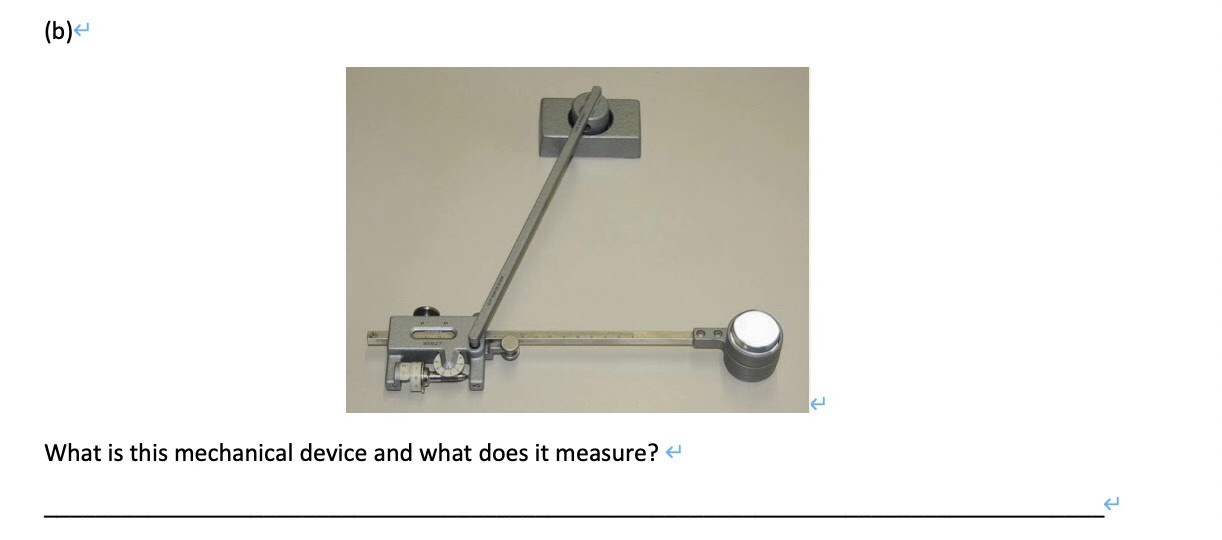
I’m thinking some kind of torque measuring device but I can’t find confirmation.
-
1$\begingroup$ Please add more detail. Where have you seen this device? What was around it? What document does this come from? $\endgroup$– hazzey ♦Commented Dec 18, 2020 at 20:17
-
$\begingroup$ I’m afraid I have no more info on it. I seen the question posted on a Chinese engineering forum. $\endgroup$– KanturaCommented Dec 18, 2020 at 20:22
-
1$\begingroup$ Looks like some pretty tight precision parts and a few graduated scales, probably some sort of precision angle gauge. $\endgroup$– jkoCommented Dec 18, 2020 at 20:47
-
$\begingroup$ The picture is also on Wikipedia Planimeter $\endgroup$– FredCommented Dec 19, 2020 at 2:37
2 Answers
It seems to be a POLAR PLANIMETER.
It has two arms: a peg and a magnifier lens with a crosshair that you should look through to see the object you are tracing.
A polar planimeter is a device that can measure the area of a shape by tracing around its perimeter. Here is a Youtube clip with good details. Polar Planimetr
-
-
1$\begingroup$ @Kantura, thanks. one should be very old to have seen these things. $\endgroup$– kamranCommented Dec 19, 2020 at 3:09
-
1$\begingroup$ Did you use a reverse google image search like I did? $\endgroup$– hazzey ♦Commented Dec 19, 2020 at 17:32
-
1$\begingroup$ @hazzey, I have used it in the past,yes, but my phone app doesn't have it. I had used a version of this device in 1978 to estimate the area earthquake damages in Iran. I have been sharing my aerial photos with google for many years for their google earth imagery. they want to build a virtual world. $\endgroup$– kamranCommented Dec 19, 2020 at 23:24
Your picture is also on Wikipedia Planimeter.
Planimeters were used more prior to the development of computer digitizers during the 1980s. They were useful in measuring areas of cut & fill in civil engineering, such as in road works, or in determining the area mined in a open pit.
During the design stage, vertical sections would be taken through the region being cut or fill. If the sections were uniform they would be multiplied by the thickness to obtain volume of cut or fill.
If the sections weren't uniform, or in open pit work, where surveyors would provide before and after survey outlines of a region that had been mined, the volume would be found using Simpson's Rule. Areas measured using a planimeter would be multiplied by the distance between sections.
The same technique would apply to measuring the volume of fill in civil engineering or waste dumps in mining.
By the early 2000s, planimeters were generally not being used because computer digitization had taken over.
